In the ever-evolving landscape of modern technology, Geographic Information Systems (GIS) have emerged as a vital tool for analyzing, managing, and visualizing geospatial data. At the heart of GIS lies the concept of georeferencing, a foundational process that underpins the accurate representation and manipulation of spatial information. In this article, we delve into the intricacies of georeferencing, exploring its significance, methods, and real-world applications.
Understanding Georeferencing
Georeferencing, simply put, is the process of aligning spatial data to real-world geographic coordinates. This enables raw data, which may be collected from various sources like satellite imagery, paper maps, or field surveys, to be seamlessly integrated within the digital realm of GIS. Without proper georeferencing, spatial data would be mere pixels without any context or relation to the Earth’s surface.
At its core, georeferencing bridges the gap between the virtual and physical worlds. It involves assigning a Spatial Reference System (SRS) to data, which encompasses both the coordinate system (latitude and longitude) and the projection (how the spherical Earth is flattened onto a 2D plane). This SRS information ensures that disparate datasets can be accurately overlaid, analyzed, and compared, forming the basis for meaningful insights.
Methods of Georeferencing
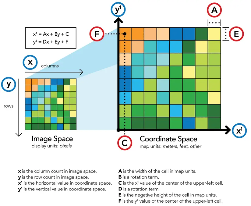
Georeferencing is a multi-step process that involves matching points on a non-georeferenced image or dataset to their corresponding real-world coordinates. Several methods are employed to achieve this alignment:
- Control Points: Control points are distinct, identifiable features that appear both in the source dataset and on a reference map or image with known coordinates. By identifying these common points, the GIS software can calculate the transformation needed to align the source data accurately. Common control points include road intersections, prominent landmarks, and distinct topographical features.
- Polynomial Transformation: Polynomial transformation involves using mathematical equations to perform the georeferencing process. Different orders of polynomial equations can be applied, with higher-order equations accommodating complex distortions. This method is suitable for datasets with irregular distortions or when linear transformations aren’t sufficient.
- Rubber Sheeting: Rubber sheeting involves using a grid-based adjustment to warp the source data until it aligns with the reference data. This method is particularly useful for correcting localized distortions in scanned paper maps or historical data.
- Least Squares Adjustment: The least squares adjustment minimizes the difference between control points in the source and reference datasets. This iterative process calculates a transformation that optimally fits all control points, providing a more accurate georeferencing solution.
Real-world Applications
Georeferencing plays a pivotal role across various domains, unlocking insights and enhancing decision-making processes. Let’s explore some compelling real-world applications:
- Urban Planning: Urban planners utilize georeferencing to create comprehensive maps that depict zoning regulations, infrastructure layouts, and land use patterns. By overlaying various datasets, such as population density, transportation networks, and environmental factors, planners can make informed decisions about the development of cities and towns.
- Environmental Analysis: Environmental scientists leverage georeferencing to study natural phenomena and track changes over time. For instance, satellite imagery can be georeferenced to monitor deforestation, glacier retreat, or coral reef degradation, aiding in the assessment of ecological shifts and their potential impacts.
- Archaeological Studies: Archaeologists use georeferencing to link excavation data with geographic locations. By accurately mapping the location of artifacts, excavation sites and historical structures, researchers can reconstruct ancient landscapes and uncover insights about past civilizations.
- Disaster Management: In disaster-prone areas, georeferencing is essential for creating hazard maps, evacuation plans, and risk assessments. By integrating data on terrain, population density, and vulnerability, emergency responders can better prepare for and respond to natural disasters like earthquakes, floods, and wildfires.
- Agriculture and Precision Farming: Farmers leverage georeferenced data to optimize crop management through precision farming techniques. By analyzing soil characteristics, weather patterns, and crop health, they can make data-driven decisions to improve yields and reduce resource waste.
- Historical Preservation: Georeferencing aids in preserving historical sites and landmarks. By accurately mapping historical buildings, monuments, and cultural sites, preservationists can monitor their condition and plan restoration efforts while maintaining the historical context.
Challenges and Considerations
While georeferencing is a powerful technique, it’s not without challenges:
- Data Quality: The accuracy of georeferencing heavily depends on the quality of control points and reference data. Errors in control points or outdated reference maps can lead to misalignments and inaccuracies.
- Distortions: Some datasets may exhibit complex distortions that are not easily rectified by simple transformation methods. In such cases, more advanced techniques or combinations of methods might be necessary.
- Projection Mismatch: Mismatches between different spatial reference systems can result in significant errors when overlaying datasets. Ensuring consistent projections across datasets is crucial for accurate analysis.
- Automation vs. Manual Adjustment: Automated georeferencing tools can expedite the process, but manual adjustments might be required for intricate datasets or historical maps that lack precise control points.
Conclusion
Georeferencing is the linchpin that empowers GIS to transform raw spatial data into actionable insights. Its role in accurately aligning disparate datasets and enabling meaningful analysis cannot be understated. From urban planning to disaster management, environmental analysis to agriculture, georeferencing shapes the way we understand and interact with our world.
As GIS technology continues to advance, georeferencing methods are becoming more sophisticated, catering to a wider array of spatial datasets and challenges. By understanding the nuances of georeferencing and its applications, professionals across various industries can harness the true potential of geospatial data and contribute to informed decision-making processes that shape our future.